Posts

Showing posts with the label oahu-waianae

Keaau Middle -- Ohikilolo -- Bob Burd

Image
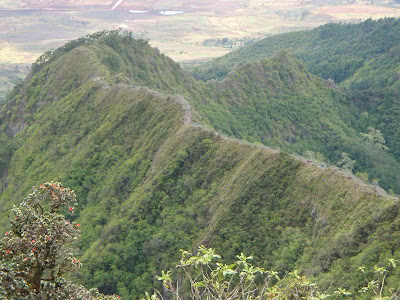
These unofficially named summits are located in the Waianae Range of western Oahu, on ridgelines separating the Makua, Ohikilolo and Makaha Valleys. Access is from the west in Ohikilolo Valley, at the end of Keaau Homesteads Rd. The looping hike is 6.2mi in length with 3,500ft of gain. Nandor had provided me a GPX track that was super helpful and all I needed to complete the hike in a bit over 5 hours. Unlike the previous day's muddy hike to Ka'ala, today's weather was much better and the entire route dry. Great views all day long, too. I started just after 8a, having driven Keaau Homesteads Rd as far as I could, through a first open gate at the highway, but stopped by a second gate just past Ohikilolo Adventure Park (not what you might think - this is a horseback riding establishment). I parked on the wide, mowed shoulder outside the adventure park and started up the road from there.  Ample signs let you know this is a hunting area, the current month for gamebirds only.

Kawiwiunu (Puu Kawiwi to Kamaileunu) -- Pete Clines (2011)

Image
Finally got to do the crossover between Kawiwi and Kamaileunu! I have been interested in this route since hearing that Al Miller did it years (and years) ago. I was supposed to take some of the gang up there back in January, but I got sick and spent that weekend in bed. Then the weather was just uncooperative all the recent Sundays. But this past weekend we had the trades back and the forecast was for less rain, so we (Kevin, Duc, August, and I) went for it. Below is the route starting from the usual trailhead in Waianae Valley. The blue arrow marks the notch which is where it gets particularly exciting. After leaving my car near the Kamaileunu trailhead, we rode in Duc’s car to our starting point, and set off up the paved road at 8:30ish. The road was wet and slick - not a good sign as we would prefer dry conditions for a safe climb up and across. From the curve in the road we ducked into the forest on the path to the base of Kawiwi. Most of my ribbons from last year were g

Kalena, Ka'ala, Kamaohanui -- Jeremy Kreis

Image
Probably the first time the traverse from Kolekole Pass to Pu'u Kalena to Mauna Ka'ala to Kamaohanui to Waialua has been done.  The doers were Jeremy Kreis, Matt Church (left, below), and Jonathan O'Hagan (right, below).  The deed was done in July 2011.  Here is Jeremy's summation of the outing, along with some pics he took. Connected the three highest peaks on the island. Original plan was to follow Ka'ala East to Kamaohanui, and then go down Kalena. We had access problems so we started at Kalena instead. Got lost in the Ka'ala Bog so we had to climb a tree to find the FAA Installation. The descent down to Kamaohanui was not what I expected. There is a fence about halfway down, and the climb to Kamaohanui was not very exciting. At the summit, we were debating about where to go down, and, unfortunately, Ka'ala East did not happen. That jagged ridge will have to wait. We followed a fenced ridge down to Waialua instead. Came out on Farrington Highway

The Extreme Exploits of Marcus Griego

Image
In reading about the recent descent of Lanihuli to the Kalihi Saddle , it was clearly apparent that the lead hiker was Marcus Griego who recently reported the following: Since then, I've done quite a few more. Piliwale down the Notches. Kalihi Saddle to Lanihuli, no ropes. Free climbed down the door stop & pimple. He also indicated the following which included a query: I recently free climbed up the "back side" (of No Name peak) .The 60 foot wall (from Makaha Valley). Was wondering if anybody else has done it before me? Pictured above are the backside of NoName Peak from Makaha, with the topmost photo (by Dave Concepcion) being Marcus on the climb. I'm guessing Marcus is the first. Anyone know? In any case, congrats and good job.

Po'o Nia (Bolohead) Ridge Conquered

Image
Kaleo Lancaster and company have established a route to/from the apex of the Waianae Range (aka Mauna Kaala) via Bolohead Ridge, so christened by Waianae Steve Rohrmayr because of a extreme rockface on this "trail" that appears like the head of a hairless man. Perhaps this trail/route might be called Po'o Nia Ridge ( the Hawaiian translation for bald head) . Whatever the case, Bolohead/Po'o Nia has been done as documented by David Chatsuthiphan at Unreal Hawaii . The pic at left (taken by Nate Rubio ) is Kaleo climbing Po'o Nia. Congrats and good work, people!

Kawiwi to Kamaileunu (Kawiwiunu) by Pete Clines

Finally got to do the crossover between Kawiwi and Kamaileunu! I have been interested in this route since hearing that Al Miller did it years (and years) ago. I was supposed to take some of the gang up there back in January, but I got sick and spent that weekend in bed. Then the weather was just uncooperative all the recent Sundays. But this past weekend we had the trades back and the forecast was for less rain, so we (Kevin, Duc, August, and I) went for it. Below is the route starting from the usual trailhead in Waianae Valley. The blue arrow marks the notch which is where it gets particularly exciting. After leaving my car near the Kamaileunu trailhead, we rode in Duc’s car to our starting point, and set off up the paved road at 8:30ish. The road was wet and slick - not a good sign as we would prefer dry conditions for a safe climb up and across. From the curve in the road we ducked into the forest on the path to the base of Kawiwi. Most of my ribbons from last ye

Waialua to Kaala to Dodge Ridge to Kamaileunu to Waianae -- Pat Rorie

Hike date: 22 December 2002. Pete Clines and I did a monster day hike yesterday. For those who don't like to read long write-ups, I offer a short version of our trek followed by a longer one, filled with pertinent information. Short version: Starting from Farrington Hwy in Waialua, Pete and I climbed to the summit of Mount Ka'ala via the Dupont Trail, traversed Ka'ala, tramped along the spine of Kamaile'unu Ridge, dropped down to the floor of Makaha Valley via the ancient Hawaiian Kumaipo Trail, regained the spine of Kamaile'unu via a spur ridge some of us have dubbed "Fred Dodge Ridge" and then cruised down Kamaile'unu Ridge to Maiuu Road in Wai'anae. Total elevation gain on the day - 6,400 feet. The outing provided numerous rewards/accomplishments: we reached the highest point on O'ahu, we traversed the island of O'ahu, we enjoyed outstanding views most of the day, we had a great workout, we were exposed to a wealth of native fl

Pohakea Pass to Pu'u Kaua -- Lad Spinner

Image
Hike date: January 2000 Today I went hiking in the Waianae range with four other folks, including my buddy Cleve Rich. Also hiking with us were Kawika Bew, Ming Ching, and Ming's friend Jean. We met at 8 at the Kunia Golf Course, then set off on the dirt roads thru the pineapple fields directly across Kunia Road from the golf course driveway. We encountered pine field workers but they did not hassle us and we continued toward the mountain, following new/old jeep roads at times and wading through California grass at others. Eventually we reached a spur ridge that climbed up toward the crest just to the right of Pohakea Pass. At the 1800 foot level (just got a new Casio Pathfinder altimeter watch), we hit the Honouliuli contour trail (HCT). Kawika and Cleve were ahead at this point and they missed the left turn they were supposed to make at the HCT. Instead, they kept climbing the spur ridge and, after some very steep climbing near the top, eventually reached the Waianae

Ohikilolo via Keaau Ridge -- Pat Rorie

Image
Hike date : January 2000 "Winter is for the Wai'anaes" is a saying I have a firm belief in, and I enjoy hiking the Wai'anae Range (Leeward Coast) because of its stark contrast to the Ko'olaus - dry, rocky, open terrain vs. muddy, heavily vegetated territory. Having sat around watching football games on Saturday and Sunday afternoons resting my left knee, I decided to venture out of my humble Waikele abode Monday (Martin Luther King, Jr.'s birthday) to visit one of my favorite locales on O'ahu, the Ohikilolo triangular peak. I've reached the triangular peak in the past via Ohikilolo Ridge (twice), Kea'au Ridge commencing from the region mauka of the former First Hawaiian Bank (FHB) rec center (three times), the entire Kea'au Ridge commencing from the Makaha surfing beach, but never via Kea'au Middle Ridge. Dayle Turner recently posted a very good route description of Kea'au Middle , so I'll skip the specifics unless deemed n